Mastering Land Visualization with DOODIN's Advanced Zoom and Rotate Features

In the world of land trading and real estate development, understanding the characteristics of land is crucial. DOODIN's advanced zoom and rotate features on the "Measurement" page transform land visualization and analysis, making complex terrain analysis simple and convenient for professional land traders.

Experience Your Land in Every Dimension with DOODIN
At first glance, a land plot might seem like a simple rectangle. However, in a standard 2D view, you might miss the true shape of the land.
DOODIN revolutionizes land surveying by offering comprehensive 2D and 3D visualization capabilities that transform how you understand and evaluate property. Whether you're an investor, landowner, farmer, or developer planning your next project, our specialized tools provide precise valuation and potential assessment of your land.
-
3D Visualization:
- Examine detailed contour lines showing precise elevation changes
- Understand land potential with real-time slope analysis
- Navigate 360-degree views for complete property inspection
-
Professional Boundary Measurement:
- Crystal-clear distance indicators for precise planning
- High-precision digital area measurement system
- Real-time distance and area calculations
- Instant measurement recording and sharing capabilities
Transform Your Map View with Filters
A land plot might appear as a simple rectangle in a standard 2D view, but you could miss important details about its true shape.
Use filters to adjust your view and add the information you need.
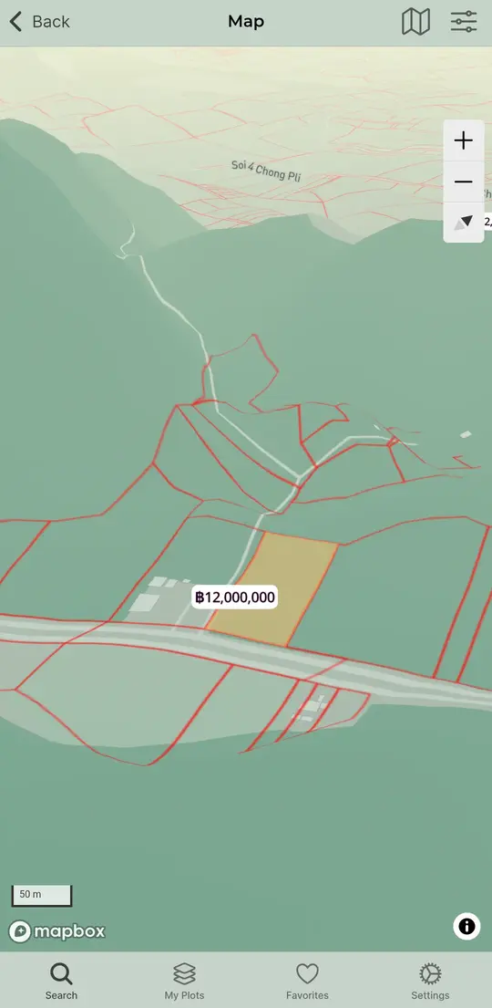
Light Mode
- Ideal for daytime use or in well-lit environments.
Night Mode
- Perfect for nighttime use or in low-light areas.
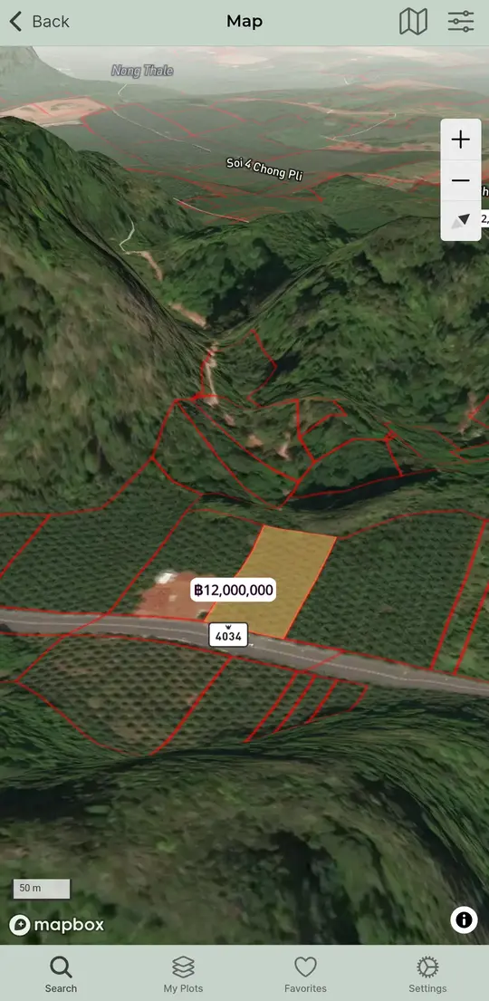
Satellite View
- Great for comparing aerial maps.
- Use to compare map data with what you see on the ground.
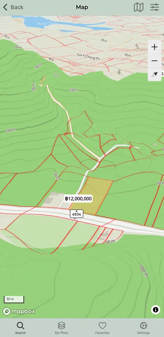
Terrain View
- Best for geographical exploration.
- Includes contour lines to show elevation levels.
With DOODIN, What Can You Analyze?
Overview
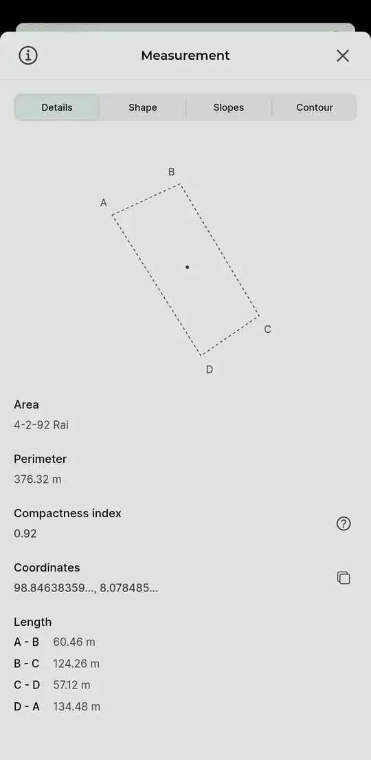
- Land polygon: Displays the land shape with boundary lines, center point, and corner markers.
- Size and perimeter: Shows land size and perimeter in selected units (feet, meters).
- Compactness index: Measures the symmetry of the land (maximum value = 1).
- Coordinates: Coordinates of the land's center point.
- Distance: Displays distances at each corner of the land in selected units (feet, meters).
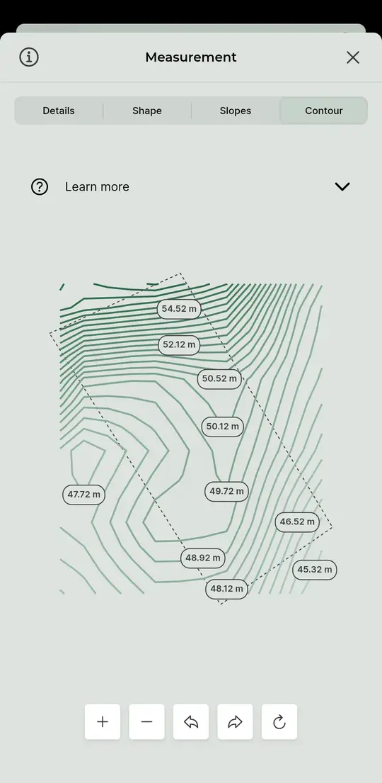
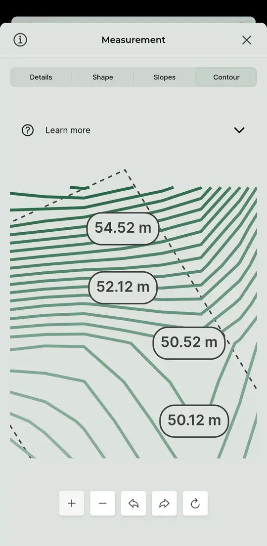
Contour Lines
- Land polygon: Displays the land shape with boundary lines.
- Elevation display: Closer contour lines indicate steeper slopes, while wider lines indicate gentler slopes.
- Hills and depressions: Inner circles with higher levels indicate hills, while lower levels indicate depressions (shown with hatching).
- Labels: Contour lines are labeled to show elevation changes.
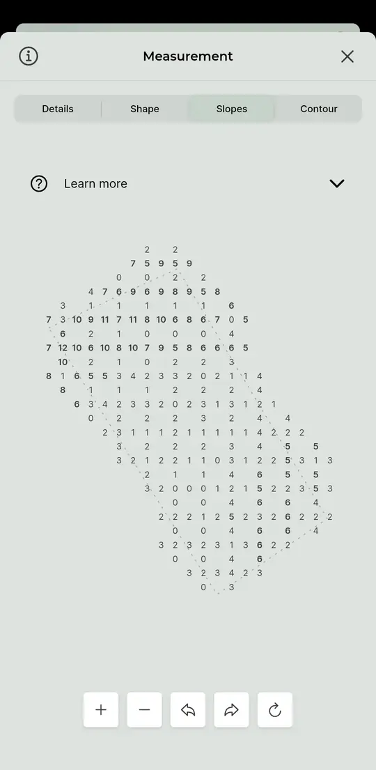
Slopes
- Land polygon: Displays the land shape with boundary lines.
- Color-coded labels: Shows gentle slopes (light color), moderate slopes (medium color), and steep slopes (dark color).
- Labels: Displays slope values in degrees for easy reading.
Shape
- Land polygon: Displays the land shape with boundary lines, center point, and corner markers.
New Features from DOODIN
Making Measurements Easier


Rotate Feature
Experience the freedom to view your land from any angle with the rotate feature.
- Rotate 360 degrees to analyze the terrain from all directions.
- Seamlessly switch between 2D and 3D views for a realistic perspective.
- Clearly see slopes to confidently plan land use.
- Enhanced terrain view for a better understanding of the actual area without switching apps.
Access the measurement page by:
- Tapping on the land boundary section in the land list page.
- Tapping on details in the land boundary drawing page.
- Selecting the desired page to view data.
- Using arrow buttons to rotate clockwise or counterclockwise.
- Pressing the circular arrow button to reset the rotation.
Zoom Feature
- Experience a new level of detail with DOODIN's zoom feature, allowing you to explore land plots in every detail.
- Detailed contour lines for quick terrain understanding.
- Accurate distance measurement for precise planning.
- Elevation levels at key points across the area.
Access the measurement page by:
- Tapping on the land boundary section in the land list page.
- Tapping on details in the land boundary drawing page.
- Selecting the desired page to view data.
- Using the plus (+) or minus (-) buttons to zoom in or out.
- Pressing the circular arrow button to reset to the default view.
Measure Land Boundaries Accurately to the Last Tarang Wa
DOODIN puts professional surveying capabilities in your pocket. Our user-friendly interface makes complex measurements as simple as touching your screen.
Want to master DOODIN? Check out our comprehensive guide to unlock the full potential of your land management toolkit. 🔍 Read the guide to learn about all of DOODIN's features.
Join the Revolution – Download DOODIN Today
Be part of the revolution in land trading in Thailand. Whether you're buying, selling, or managing land and real estate, DOODIN makes it easier, more convenient, and more efficient. DOODIN is the app you need. Download now on the App Store or Google Play.
Have questions or stories to share? Be part of DOODIN. Contact us directly and follow our blog for more real estate tips.
Trading land is easy with DOODIN.
We welcome your feedback. Let us know if there's anything you'd like us to improve.