Drawing Land Boundaries
This guide helps you to understand and implement the land boundary drawing feature in the DOODIN App.

Using the Map-Drawing Feature
The map-drawing feature in the DOODIN App allows you to define the precise boundaries of your property directly on the map.
Viewing the Map and Geolocating
When you first access the map-drawing tool, you will see a detailed map view of Thailand. You can choose to geolocate your current position by clicking the geolocation button below the drawing tools, or you can search for a specific location or city by clicking the search icon.
Header
Navigation and Tools
- Search Button: Opens the search modal to find locations.
- Map Filter: Allows you to apply filters to the map display.
- Information Button: Starts a guided tour of the map controls.
Drawing Boundaries
Accessing the Drawing Tool
- Open the DOODIN App and navigate to the map view for your property plot.
- Tap on the drawing tool icon located on the map interface.
Drawing a Polygon
- Select Drawing Tool: Choose the polygon drawing tool to start creating boundaries.
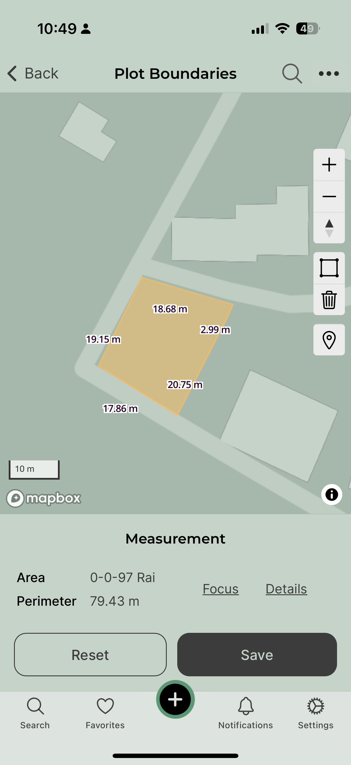
- Draw Boundaries: Tap on the map to create points that define the edges of your polygon. Make sure to close the polygon by connecting the last point to the first.
- Edit: Adjust the boundary points by dragging them to the desired location.
Saving Your Work
- After drawing your boundaries, save your work by tapping the 'Save' button. This saves the polygon as the boundary of your property.
- If the boundary exceeds the maximum allowed area, you'll receive a notification to adjust the size.
Resetting the Map
- If you need to start over, you can reset the drawing by tapping the 'Reset' button. This will clear the current boundaries and allow you to redraw them.
Viewing and Managing Boundaries
Viewing Measurements
- Area and Perimeter: The app displays the area and perimeter of the drawn boundary, helping you to understand the size and shape of your plot.
- Details Button: Tap on 'Details' to get a more comprehensive overview of the geometric properties. See also measurement.
Fitting the Map to Boundaries
- Zoom to Fit: Use the 'Zoom to Fit' button to adjust the map view so the entire boundary fits within the screen. This is helpful for reviewing the entire plot.
Displaying Nearby Polygons
- If there are any nearby property boundaries, the app can display these to help you ensure that your boundaries do not overlap with neighboring plots.
If the plot overlaps with another plot that is published on DOODIN, you can still save the boundaries if the plot status is draft or unpublished. When the status is published or you want to publish it, the app will show an error because we do not allow overlapping boundaries. If you believe the boundaries are 100% correct, you can contact the support team to review your case.
Tools and Controls
Map Controls
- Zoom In/Out: Buttons to zoom the map in and out, making it easier to draw and view your boundaries.
- Compass: Adjust the orientation of the map.
- Geolocation: Center the map on your current location for easier boundary drawing.
Import and Export Boundaries
- Import Boundaries: Import your plot boundaries from KML and GeoJSON formats with automatic validation.
- Export Boundaries: Download your created plot boundaries in KML or GeoJSON format.
You can use the import feature completely free of charge, allowing you to easily upload plot boundaries in KML or GeoJSON formats. However, the export feature, which lets you download your created plot boundaries, is available exclusively with a premium subscription.
Additional Features
- Start Tour: For new users, the 'Start Tour' button provides a guided overview of all map controls and features.
- Search and Filter: Utilize the search and filter buttons to locate specific areas or adjust the visibility of map elements.
By understanding and utilizing these tools and steps, you can effectively define and manage the boundaries of your property using the DOODIN App. Follow this guide to ensure accurate and efficient use of the map-drawing feature.